Borrasca Oriana: The anatomy of an Atlantic cyclone and the siege of the Iberian Peninsula
Spain once again comes face to face with the power of the Atlantic. Borrasca Oriana, a deep low-pressure system that has formed over chilly ocean waters, has hit land with a force that has surprised even emergency services prepared for difficult conditions. This is no ordinary rain front - it is a complex physical phenomenon that is turning the country's weather map into a testing ground for meteorologists and a test of endurance for infrastructure.
1: The mechanism of the element: What is borrasca?
In meteorological terminology, borrasca (baric low) is an area of reduced atmospheric pressure, characterized by cyclonic movement of air masses. In the case of Oriana, we are dealing with the so-called. a deep low**, in the center of which the pressure drops dramatically in a short period of time.
This phenomenon arises at the meeting of two radically different worlds: cold, dense polar air coming down from the north and warm, moist tropical air. When these two masses collide over the Atlantic, baroclinic instability occurs. A vortex is formed, which, like a giant vacuum cleaner, sucks moisture from the ocean and transports it over Europe. The greater the temperature difference between the masses, the lower the pressure in the "eye" of the low, and the more powerful the wind, which tries to compensate for the difference.
2. Why is Spain a "target" for lows?
Many observers ask why Spain, associated with sunshine, so regularly falls victim to weather apocalypses. The answer lies in the unique geography of the Iberian Peninsula, which acts as a "sea idol" for all of Western Europe.
- the Atlantic Gateway: Spain lies in the direct path of the so-called. Jet Stream (stream current). As this strong air current in the upper atmosphere meanders southward, it directs Atlantic lows straight toward Galicia and Portugal.
- Orographic Effect (Mountain Barriers): Spain is a country with extremely varied terrain. When Oriana hits the Cordillera Cantabria or Central System, air masses are forced to rise rapidly. There is a cooling of water vapor and its rapid condensation. This is why precipitation in the mountains is many times higher than in the lowlands - the mountains literally "wring" the clouds from the water.
- Collision with the Azores High: Often there is a situation in which the powerful Azores High blocks the path of the low, but as soon as it weakens, a corridor opens up through which the borrasca enters with enormous kinetic energy.
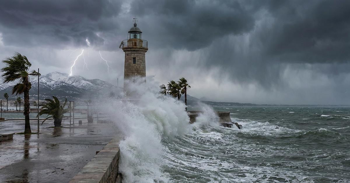
3: The effects of Oriana: From snow paralysis to coastal storms
Oriana is not choosing its means. In the northwest, in Galicia and Asturias, the main threat is flash floods and landslides. Water-saturated soil is unable to absorb another hundreds of liters per square meter.
In contrast, in the higher elevations - from the Pyrenees to the Sierra Nevada - the borrasca shows its winter face. When the snow limit falls below 1,000 meters, it means mountain villages are cut off from the world and key transportation routes are paralyzed. However, it is the wind that is the most destructive element of Oriana. Gusts in excess of 100-120 kilometers per hour on the coasts and in the southeastern regions (Almería, Balearic Islands) cause not only damage to infrastructure, but also the phenomenon of sea swell, destroying coastal boulevards.
4: Threat calendar: When to expect the worst?
Borrasca-type phenomena have a distinct seasonality in Spain. The highest activity is from November to March. This is when the temperature gradient between the cooled continent and the still relatively warm ocean is greatest, providing fuel for cyclones.
However, it's worth noting a disturbing trend: due to global warming, lows like Oriana are becoming increasingly unpredictable. A warmer atmosphere is able to "hold" more water vapor, which means that precipitation is becoming more extreme, and phenomena that were once considered rare are becoming the new normal of Spanish winters.
5. Summary: The fight for security
The Oriana borrasca situation is not just making headlines in the media, but a real challenge for the country's logistics. AEMET, using a system of color codes (yellow, orange, red), is trying to minimize the risk, but in a clash with such a massive phenomenon, the ultimate responsibility lies with prevention and the sanity of citizens.
Understanding that the borrasca is not "bad weather," but a powerful thermodynamic machine, makes it possible to better prepare for the next hits of the element, which will return with increasing regularity in the era of climate change.